Entertainment Magazine> Tucson> Attractions> Oro Valley> Catalina State Park
Hiking and camping in Catalina State Park
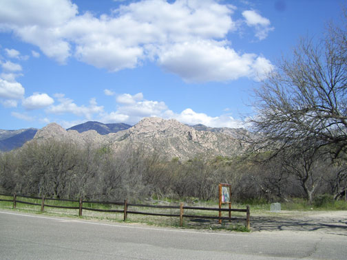
The Catalina State Park is located in the Coronado National Forest along the west side of the Catalina Mountains. There are several well marked hiking trails for a short or long hike. A list of trails are provided below.
Camping is allowed in designated areas. There are handicap accessible trails and picnic areas. Pick up a copy of the Catalina State Park trail map at the Ranger Station.
There is a $6 per
vehicle fee to park, which includes a map of trails for hiking and
camping and a Catalina State Park Trail Guide. Annual passes are available for frequent hikers and campers.
The picnic area has
picnic tables, BBQ grills, modern flush restroom, and one 20x40 foot
shade ramada. Picnic area facilities are available first-come,
first-served. No reservations. Day use hours are 5 am-10 pm.
Catalina Adventure Program in October
An Environmental
Education Program for Grades 1–3., The Catalina Adventure Program, is a
2-hour environmental awareness program designed for sensory learning for
grades 1–3. This participatory and interactive field trip, led by
trained naturalists, focuses on developing an awareness of nature
through the senses. Appreciation of the natural world and our
relationship to it is emphasized during a series of hands-on activities
along a trail in the 5,500 acre park.
Students get to
explore and learn to use all of their senses. The trail walk and
activities apply the concepts of using the five senses learned in the
classroom to improve the students’ understanding of the natural world.
Teachers receive a packet with pre- and post-visit classroom activities
to enhance the on-site experience. The materials contain specific key
concepts, teacher background information, and student activity sheets.
The Catalina Adventure Program begins in October 2010. There is
currently a fee of $2 per student.
For more information or to schedule a
trip, please contact Catalina State Park Volunteer Naturalists Joanne
and Andy Hogan at (520) 903-4367.
October 2010 Hikes at Catalina State Park
All hikes leave
from main trailhead unless noted. For all hikes, please bring water, hat
and food. Pace will be moderate. Hike listings are subject to change.
For safety reasons, four hikers are required for a hike to take place.
If poor weather, a hike may be canceled and the hike leader will phone
registered hikers ASAP before hike time. Registration is mandatory.
Please register with Gaston Meloche by 4 pm the day prior to the hike at
(520) 638-5404.
Sunday, October 3,
2010. Total miles: 6–7, Elevation change: 300’. Destination: Bluffs
& 50 year trail. Start time: 8 am (Hike starts from Equestrian
Center)
Sunday, October 10,
2010. Total miles: 6–7. Elevation change: 400’. Destination: Alamo
Canyon & West Ridges. Start time: 8 am
Sunday, October 24, 2010 hike. Total miles: 6–7. Elevation change: 1300’. Destination: Walter’s Cascade. Start time: 8 am
Sunday, October 31,
2010 hike. Total miles: 7–8. Elevation change: 300’. Destination:
Catalina’s Medium Loop. Start time: 8 am (Hike starts from Equestrian
Center).
Santa Catalina Hiking Trails
There are a half dozen, easily marked hiking trails that lead from the trail head near the main parking area.
50-Year Trail: 7.8 miles, one way. Popular with bicyclists, horseback riding and hiking.
Birding Trail: 1 mile, loop
Bridle Trail: 1.4 miles, one way
Canyon Loop Trail: 2.3 miles loop
Nature Trail: 1 mile, loop (about 45 minutes walking time).
Romero Canyon Trail: 7.2 miles one way
Romero Ruin Interpretive Trail: 3/4
mile, loop. This popular trail leads to an the Romero Ruin
archeological site with the remains of a Hohokam village site dating
back to 500 A.D. The hiking trail is located from the parking lot on the
main road near the picnic area.
Sutherland Trail: 10.8 miles one way
|
Catalina State Park Map
Select the controls to zoom in
to the hiking trails, parking. Zoom out to see the surrounding area and
print for a map of directions.
Catalina State Park Video
Use the video controls to play the video looking southwest to northwest towards Tucson.

Common Sense Hiking Tips
Follow the Trails:
Stay on the designated trails to protect surrounding wildlife. If there
is no designated trail, try using animal paths so not to disturb the
environment any further.
Don't make short cuts or "switchbacks." This will damage the area and contribute to erosion.
Sanitation: Go before you go. There are public rest rooms in the parking area. If you must leave a deposit, cover it.
Pets: All pets must be leashed. Remove pet waste in disposal bags or bury away from the trail.
Water: Bring at least one gallon of water per person per day of your trip. Drink often and take frequent breaks.
Rest: Take a brief ten minute rest for every hour of hiking. If not physically active, rest longer.
Hot Weather: Do not hike in the afternoons in the summer. Early mornings are best for hiking.
Cell Phone:
take a cell phone on your hike. If using GPS, set your location. Some
cell phone services will work in parts of the Park. To get the best
reception, don't be in a valley.
|
|
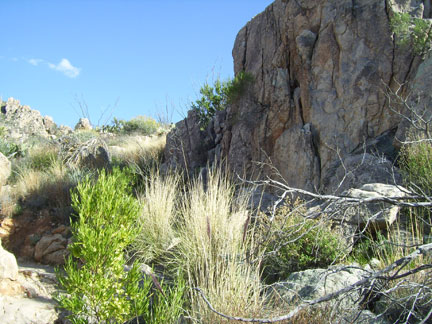
(Above) Entrance to the Catalina State Park trail head where most of the trails separate
|
Catalina State Park Hiking

The city of Tucson and Oro
Valley are blocked out by Mother Nature once you cross the nearly dried
creek bed and take a short hike along one of the many available trails
and trail loops.
History of the Catalina State Park before it became a Park
Prospectors
were attracted to the Canada del Oro region by the lure of gold in
spite of the risks from the Apaches. Reports of placer mines established
along the upper reaches of the “Canyon of Gold” continued until late in
the 1920s. Apparently not much materialized since no mining activity
has been found in Park area.
The
most successful enterprise in the general area of the Park was
ranching. The earliest known rancher within the Canada del Oro region
was Francisco Romero who was born in Tucson between 1810 and 1831, the
grandson of a Spanish soldier who had arrived in Tucson in the 1770s.
Although little is known of his childhood, he is mentioned as
establishing a ranch of 160 acres on the west side of the Catalina
Mountains in 1844 near the Canada del Oro. Romero evidentially was a
successful rancher, since he acquired additional pieces of property
including 320 acres of farmland along the Santa Cruz River west of
Flowing Wells and land on Main Street in the downtown Tucson business
district.
Francisco
and his wife, Victoria, had three children, one of whom became a
rancher. His name was Fabian, born in 1864, and he is credited as the
founder of Rancho Romero. His ranch is reported to have been 4800 acres.
According to a map of Pima County drawn up in 1873, the Romero Ranch
buildings were shown as located in section 4 that is within the Park
boundary. A capped well and a concrete base for a water storage tank are
the only remains that were found at that location. Fabian and his wife,
Benardina had five children but it is not known if any of the children
took ownership of the ranch before it passed out of family ownership.
Romero Pass and Romero Canyon were named after the family.
Another
rancher to follow the Romero family to the Canada del Oro region was
George Pusch, a young German immigrant and his partner, John Zellweger.
They bought a large ranch in 1874 that was later named the Steam Pump
Ranch due to the installation of a steam pump to ensure a predictable
water supply. Pusch died in 1921 and the cattle ranch passed out of the
family’s possession.
The
Sutherland family also ranched in the vicinity of the Canada del Oro
Wash. William Henry Sutherland was the general superintendent and part
owner of the Arizona Stage Company. Later, he purchased the Canada del
Oro Ranch. According to the 1922 Pima County Highway Department map. The
Sutherland ranch house was located in the northwest corner of Section
26, which lies within the central section of the Park. The Sutherland
Wash, the major tributary of the Canada del Oro Wash that flows through
the Park, was named for this family.
The
history of the Park land is uncertain from the 1920s until the 1940s
when J.E. McAdams purchased 4100 acres that he called Rancho Romero. His
property is believed to contain parcels that had been owned by the
Romero and Sutherland families. The McAdams family owned the land until
1971 when it was sold to Ratliff, Miller and Muhr Investments, Inc., who
developed the plan to convert the ranch into a self-contained
community. This plan was given the Pima County Planning and Zoning with
the request to rezone the land.
Source: Arizona State Parks http://azstateparks.com/parks/cata/history.html
Arizona State Parks: Catalina State Park
|
|
|
|
  Camping World Camping World
|
Authentic salsa from El Charro Cafe in
Tucson, AZ. Contains: crushed tomatoes (tomatoes, salt, citric acid),
water, salsa (onions, salt, garlic, white vinegar, canola oil, chiltipin
pepper, oregano), tomato puree (water, tomato paste citric acid),
citric acid.
|
|